Thanks to Alison, for helping us to correct this text.
Day 1: Saturday, March 27th, 2010:
Santiago - La Serena
Ver Santiago - Los Vilos - La Serena en un mapa ampliado
As we often do when we start a route, we woke up early and no one knows why we did not depart until 8:40 A.M.
We loaded gas at the station in the north exit of Santiago, because it was our first trip in the Transalp, I wanted to see the performance only with highway data, and I didn’t load in Santiago itself.

Gas Station at north exit of Santiago, The Rubia (blonde) still it’s clean.

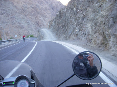
A little bit to the north of Santiago.
We filled up with gas at the gas station in route 5 near Los Vilos, happy to have reached so far with only one tank of gas.
I’m starting to calculate the performance: about 20 Km/l, with the 17 liters of the Rubia ’s tank we should be able to get to La Serena.
We stop to lunch in Los Vilos, we ate some scallop pie opposite San Pedro Dock, they were not bad.


San Pedro Dock, in Los Vilos.
After, I don’t know how many hours, we arrived at the gas station called Top Stop, in the kilometer 260 in the route 5 (north)..... I was still thinking about something that had been in my head from Los Vilos... the performance... the gas should be enough to reach La Serena. After reviewing the maths a thousand times I decided not to refuel... I trust the Rubia will not let us down.
The wind in the zones of Canela Baja, Talinay and Socos were really strong, the aerodymamics of the Transalp helps a lot, no effort is required to counteract it’s effect on the Rubia.
As we are cautious, we did that part slowly...
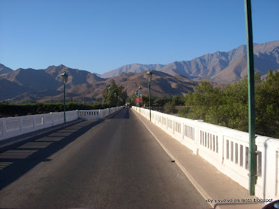
... and the Limarí bridge... aarggh!!.... there the wind is really terrible, we passed quite slowly and we were worried... anyone who travels by that zone must be careful of the wind in the bridges. Look for a weathercock in the middle of the bridges that indicates the strength of the wind. Also, it is a great advantage to know the direction from where the wind will hit the bike in advance.
I don’t know where in route 5’s kilometer the fuel reserve’s light turned on… “There are still some kilometers until we get to La Serena”. I thought “There are about 40 kilometers left”… I rechecked the performance of the Rubia, several times… “I’m not sure how many litres the reserve has… 2.7 litres I think. If there are 2.5 liters, It should be enough for another 50 kilometers… it must arrive!!”
We arrived to Coquimbo at 18:30 hrs. It alleviated me to get to the gas station, my mathematics weren’t wrong, we arrived! (For those who don’t know, La Serena and Coquimbo are two merged cities, so, to reach Coquimbo is like to reach La Serena)
We charged 12,8 liters of gas… I have started to doubt that the tank’s capacity is 17 liters.
We arrived to La Serena, the end of the first day it’s closer.

Del Mar avenue, La Serena.
After 10 hours mounted on the Rubia, we still had energy, we walked around the beach. The comfort of Transalp is undeniable… I like my new bike!
That night we camped in La Serena, to be honest we don’t think it is an interesting place, but it is a comfortable place to stop. To walk in the beach is always relaxing.
It feels good to travel from Santiago to la Serena and that the bike only needed gas once.
Day 2: Sunday, March 28th, 2010
La Serena - Copiapó - Bahía Inglesa
Ver Santiago - Copiapó - La Serena en un mapa ampliado
Like usual, mi negrita (Liz) made the breakfast, then we packed the equipment and headed to Copiapó at 8:40 AM, not without taking the obligatory picture with the lighthouse of La Serena.

My negrita making the breakfast in the camp zone Sole di Mare, La Serena.

The lighthouse, La Serena.

I want a house there...fan of Honda motorcycles, route to Copiapó.
In the north exit of La Serena, we must cross the “camanchaca”, a very weighty mist. Before I saw this, I didn’t understand how the people obtain water from it, but now it is clear for me.

Camanchaca, some kilometres north of La Serena.
We stopped to rest and took some photos in Cachiyuyo, a nice town, where all the people are friends, something that all the big cities would like.

In this town they have more friends than me.

Route to Copiapó.
We rested in a cabin in Bahía Inglesa, because it was low season it cost us only $20.000 CLP (about $40 USD) for both. (In high season it is $40.000 CLP or $80 USD, I think)
Day 3: Monday, March 29th, 2010
Bahía Inglesa - Copiapó - Route to Laguna Santa Rosa
We left Bahía Inglesa in the morning, we took some pictures from the motorcycle to remember and to say “I was there”, but they weren’t very pretty, that's the reason why we didn’t upload it on the blog
The next photo is the road between Bahía Inglesa and Copiapó, the extreme south of Atacama’s Desert.

Route from Bahìa Inglesa to Copiapó.
The original idea was to go to the border crossing San Francisco, mainly to see Laguna Verde. But, when we went out towards the international route by Paipote, we saw a sign, that said the next gas station was about 450 km (I don’t remember the exact number, but I remember the autonomy of La Rubia couldn’t reach it. Also it was on the other side of the cordillera, and because we didn't have the documents for La Rubia, we couldn’t have crossed even with extra gas.
The border cross San Francisco is about 250 km, therefore the gas was not enough to go and come back. In order to go to Laguna Verde, it wasn’t enough either!
So, we refueled in Paipote (about 8 km from Copiapó) and we bought a five litre can of distilled water to fill it up with gas, because with Rubia’s tank, we could only go so far.
Liz carried the can in her lap, next time we should be better equipped for extra gas.
“I still hope to see Laguna Verde, maybe I can get some gas in the cordillera”.


Taking a rest on road to Laguna Santa Rosa

Francisco drinking Rubia’s drink.

Our first off road route, not too rough yet. Quebrada de Paipote (Paipote Stream)
The track to Laguna Santa Rosa was very bad (or so we thought… how naïve!). It had gravel and some “chuscas” (a hole in the road filled with sand). For this reason, we went between 30 and 50 km/h (It was our first time off road, and the first time always hurts hahaha).
When the night came, we camped next to the track. It was our first time camping in the road without the comforts of an official camping site.
We learned an important lesson: Don’t camp near houses in the mountain. The farm animals, turn this place into an “animal poo fest”.
A second lesson was to ensure a good place to camp before night falls, if you are away from civilization.
Day 4: Tuesday, March 30th, 2010
Road to Laguna Santa Rosa - Salar de Maricunga - Copiapó
Ver Salar de Maricunga en un mapa ampliado
This night was really windy. The tent peg came off (it isn’t designed for sand). I had to put the backpack in the top corner of my head in order to sleep. We woke up a lot of times in the night. The good thing about this is that we got up early.
The most important thing in the next photo is neither the moon, the mountain plants nor the motorcycle, it’s that the tent is normally symmetrical!


Camp in the mountains, Paipote Stream.
This was our heaviest day. We suffered the harshness of the terrain and the altitude. Besides, the day was long; we left the camp at 9:00 AM and arrived to Copiapó at 9:00 PM.
Now the road was really, really bad, metres long chuscas. In fact to cross them, Liz got down from the Rubia and I passed them in first gear, with a little bit of pressure on the clutch and helping myself with my feet.
After hours of a hell’s path ascending, we were exhausted! It was my first hard dirty route, actually. A long and steep slope started… a new worry came to me “and how do I stop the Rubia if the wheels get stuck and the Rubia spins all the way down?… So, I will go down with my foot on the rear brake”.
Suddenly Liz said “stop!, stop!”, I got frightened, I thought something had happened to the Rubia, maybe some part of it broke and Liz saw it. When I stopped, Liz said “look!.. an unforgettable postcard”:

Our first sight of Laguna Santa Rosa
The picture before was taken at 4.000 masl. It was our first sight of Laguna Santa Rosa, a beautiful valley and a wonderful lake. In the photograph the lake almost doesn’t appear, sadly.
This landscape encouraged us to keep going, “in that beautiful place we will have lunch”.
We finally arrived to Laguna Santa Rosa (3800 masl), I will not bore you with words, next some pictures:


At last, Laguna Santa Rosa.

The Vicuñas live freely in this place.


Flamingos in their natural habitat.
Sadly, the camera’s battery died, the remaining pictures of this day were taken with Liz’s cell phone, it takes quite good pictures for a cell phone, but not as good as the ones from the camera, “we will lose lots of details”.
We stayed for a while at the lake, we saw a house and we thought we could get some water (we only had one litre at that time) or gas there, with extra gas we could go to Laguna Verde. We walked about 600 metres, we felt then for the very first time (consciously at least) the effects of the altitude.
In fact, Liz had to rest half way, then she met me at the cabin.
It turned out the cabin was a CONAF’s shelter, there wasn’t anybody around to ask for anything. After the disappointment we laughed about this, then we were thankful there was at least a shelter. It protected us from the sun, and we had lunch there, Liz made a soup with our last litre of water.
I regret not taking a photograph of the shelter, I remember it fondly.
We headed to Salar de Maricunga (salt flat), at 2 or 3 in the afternoon.

Leaving Laguna Santa Rosa (St Rose’s Lake)
And we thought the route to the lake was bad! Aarggh… Who told us we were adventurers? Now, the road had some bigger chuscas and many long and soft, sandy stretches.
The terrain was so bad, that it didn´t make any sense for Liz to get down to walk. She would have had to walk many kilometres, so we didn’t separate again (the three of us). The Rubia behaved incredibly.
In the begining, the movement of the back wheel scared me. It moved from side to side, like a pendulum. “Besides if we fell, something wrong would have happend to my ladies”. I tried to think: “ It’s OK, the road is soft, we are going ridiculously slowly… on other occasions we have fallen driving faster ”
But, at 3800 m.a.s.l, without water, with harsh sunlight and after many hours fighting to move on, reasoning isn’t a great help. On top of that, in a few hours we arrived to a fork, which track to take? From the lake, we didn´t see any sign. We decided to continue on the widest track, the same way that we came. In a few hours we were worried, “What if we aren’t going anywhere?, besides we don´t have enough water”.
A few hours later, a van passed in the opposite way and we asked the people inside. They confirmed that we were travelling in the right direction. They said to us “The border crossing San Francisco is 4 hours from here, It is located on the road that goes around the salt lake”, (maybe four hours in a 4x4 vehicle! At least we were all right).
… I forgot to ask them for water!!!, damn it!!!. We went on without any worries because we knew we were alright, but we were worried about not having any water.
“For the last few hours I have been seeing strange colors”. They weren’t really strange colors as such, but the colors changed, or something like that, it’s difficult to explain in words. I think it was psychedelic and it was because of altitude.
In my head I just had simple ideas, “move on”, “do not fall”, “how many hours of daylight do we have left? ”
After hours of a hard road using all my body to control the Rubia, we started to worry a lot, we had been very thirsty for a long time.
The landscape was amazing, the colors of the mountains were incredible: red, yellow and a little green due to little plants of about 10 centimeters high at the most.
Unfortunately I didn’t have enough time to appreciate it, because I was concentrating on driving. But I admired it when we stopped to rest and at a glance whilst driving.
Sadly, Liz’s cellphone camera could not capture this beautiful landscape in all its magnificence.
“I don’t know if I should worry about the colors I’m seeing or just enjoy it ”
In the distance we saw a truck, passing perpendicularly to the road we were on. “That road should be more busy. It should be the route we should take, as far as the guys from the van told us some hours ago. I hope we will be able to ask for help”.
We suddenly saw a red van beside a small truck … we hoped they could give us water. There was a tall guy next to the van, dressed like a guard… “We will ask for water now!!!... We are really thirsty”.
We parked close to the vehicles on the road. The truck we saw passing minutes ago was now buried in the sand, and the driver was digging up the wheel with his hands.
The guy from the van was a guard, actually. He asked us where we came from, where we were going and stuff like that… I put on my best “yes, I’m stupid, but a good person” face and asked him for water… he said he could go to Lobo-Marte’s camp to get water for us (about 10 Km away, so he said!) … What a relief!... but first, he had to wait for them to release the truck.
In a while another truck came, and with a cable they pulled and unstuck the buried truck. When this new truck came Benjamín (the guard) asked the driver for water, he gave us two personal bottles… we had never drunk water as good as that!
Benjamín told us his work is to watch that part of the route, and to take care of those passing by there. That’s because they are working on a new mine project, and the road is very bad.
Benjamín went to the camp to get more water for us, while waiting we took the next picture:

Road to Salar de Maricunga (Maricunga’s salt flat).
And Benjamín arrived with two 1.5 litres bottles as well as two personal bottles of mineral water! Besides he gave us two packs of cookies. Our saviour! We are really really grateful for his willingness to help.

Francisco y Benjamìn "Salvatore".
Acercándonos al Salar de Maricunga el aire se vehía raro, una visión muy interesante, lamentablemente como se había agotado la batería de la cámara no pudimos sacar fotos, las del celular no daban para eso.
El camino que bordeaba el Salar de Maricunga estaba a la misma altura del salar, por ello tampoco sacamos fotos de él, no habrían salido tan bien y estábamos apurados, si sacamos una de un cerro bastante extraño en el borde del salar:

Un particular cerro en el Salar de Maricunga
Bueno, y realmente por esos lados no hay mucha agua que digamos, para muestra un botón: a continuación una foto del lavamanos en el complejo fronterizo San Francisco:

Sofisticado mecanismo para proveer agua en el Paso San Francisco
Descansamos en el complejo fronterizo, comimos algunas galletas (gracias Benjamín!) y enfilamos rumbo a Copiapó, poco mas abajo de Mantos de Oro (compañia minera) nos pilló la noche.
El camino era interminable y muy aburido, el cansancio nos pasaba la cuenta, el camino en la oscuridad era muy monótono, por suerte la adrenalina que había generado durante el día evitaba que me diera sueño. Ahora, haciendo nuestras memorias del viaje reconozco ese tramo como el único desagradable de la ruta. El camino ni siquiera tenía reflectantes en sus costados, para entretener la vista.
Llegamos a la estación de servicio en Paipote como a las 9:00 PM... nos tomó 2 días hacer un recorrido de 387 Km... estamos muertos de cansancio... pero valió la pena, vimos lugares increíbles, y el camino nos hizo sufrir a los tres... pero fue muy entretenido.
Día 5: Miércoles 31 de marzo 2010
Copiapó - Vallenar - Alto del Carmen - San Félix
Tomamos desayuno en el hotel y partimos a medio día. Aprovechamos la mayor cantidad de horas posible la comodidad de una cama.
Nuestra idea original era ir a un pequeño pueblo al oeste de La Serena, llamado Pisco Elqui, donde hay al menos una fabrica artesanal de pisco, y descansar allí dos noches. Hace algunos meses tratamos de ir pero no pudimos llegar, pero eso es para otra historia.

Tren cruzando el extremo sur del Desierto de Atacama
Paramos a almorzar en Vallenar, y me puse a estudiar el mapa de la zona, para ver donde podríamos ir, puesto que nos quedaban varios días de vacaciones.
En el mapa encontré un pueblo hacia el interior de Vallenar llamado Alto del Carmen... seguro hacen allí el pisco Alto del Carmen!! ... ese es mi pisco de producción en masa favorito... lógicamente decidimos ir a ese pueblo.
Después recordé mi pisco artesanal favorito, el Horcón Quemado, le preguntamos al mozo del restaurante y nos dijo que ese pisco lo hacen en San Félix, un pueblecito a unos 25 Km de Alto del Carmen... suuuper!!... pues para allá nos vamos, según mis cálculos temenos tiempo para ir, volver y después ir a Pisco Elqui y correr hacia Santiago.
El mozo también nos dijo que el pisco Alto del Carmen ya no lo hacen en el pueblo Alto del Carmen, pero que se puede visitar la fábrica, lugar en que recolectan el jugo de las uvas para enviarlo a otra fábrica para hacer el pisco.
La ruta de Vallenar a Alto del Carmen es exquisita, curvas deliciosas y muy lindo paisaje, en general con poco tráfico.
Lo único malo, es que los locales a veces se pasan a la pista en sentido contrario en las curvas, confiando en que nadie vendrá por dicha pista, hay que andar con cuidado, yo tocaba la bocina en las curvas más cerradas.
Entre otras cosas vimos muy lindos parronales y el embalse Santa Juana:

Parronales en Rio Huasco, camino a Alto del Carmen

Embalse Santa Juana, camino a Alto del Carmen
Luego de una ruta muy agradable, era descansar y divertirse en la moto, llegamos a alto del Carmen.

En Alto del Carmen, frente a la planta Capel de la localidad
Después de esperar unas horas afuera de la planta pasamos a ver las instalaciones, no sacamos fotos pues supusimos que estaba prohibido, pero en realidad creo que debimos preguntar. De todos modos la planta era linda, pero no tanto como para lamentar no haber sacado fotos.
El camino a San Félix es exquisito, curva, contra curva y contra contra curva, un placer.
Llegamos a San Félix, un muy bonito pueblo, la entrada es encantadora:


Llegada a San Félix

Iglesia de San Félix
En la plaza de San Félix conocimos a Leo, un motoquero muy buena persona y muy simpático. Nos ayudó a encontrar el camping en la Granja Educativa en La Majada.
Es el mejor camping en que hemos estado, muy lindo, incluso tiene llamas sueltas (tal vez por eso), los dueños al otro lado del camino tienen un viñedo y hacen agua ardiente, pajarete y chicha.
Con Liz nos tomamos una botella de pajarete y estaba muy rica.

En la noche, Camping La granja Educativa
Nos encantó esta zona, San Félix es muy lindo, el valle y la ruta son increíbles, el camping tiene llamas sueltas... decidimos quedarnos aquí dos noches, bastante tiempo para lo que acostumbramos.
Mañana descansaremos, iremos a conocer el valle El tránsito y las pisqueras artesanales.
Día 6: 1 de abril 2o10
San Félix - Valle El Tránsito - y de vuelta a San Félix
Fuimos a San Félix, tomamos desayuno en la plaza y después fuimos a la fábrica de Horcón Quemado (a esa fecha mi pisco favorito). En Facebook anuncia que el dueño te recibe cualquier día y te hace un tour por la fábrica... pues el viejo de mi$%# nos dijo que fuéramos el sábado en la mañana.

Un naranjo en la plaza ... y está lleno de naranjas!!!

Un canal corre a un lado de la Plaza San Felix
Bastante molestos nos fuimos al Valle El Tránsito, es un valle muy lindo, pero no tanto como el Valle El Carmen... pero encontramos un caminito encantador:
Paramos a almorzar en tránsito, puesto que en el camino desde Alto del Carmen no encontramos ningún restaurant.

Iglesia en Tránsito
Luego de almorzar decidimos volver a La Majada, tal vez alcancemos a visitar la fábrica de Bou Barroeta.

Camino de El Tránsito a Alto del Carmen.
Afortunadamente alcanzamos a llegar a la fábrica de Bou Barroeta, una señora nos hizo un tour por sus instalaciones, son sorprendentemente artesanales.


Proceso de fabricación de pisco artesanal Bou Barroeta, Viña El Rosario, Alto del Carmen
Y volvimos al campamento... que exquisita ruta:
De vuelta al camping en La Majada
Fuimos a ver la bodega artesanal de la Granja Educativa, compramos otra botella de pajarete y probé el agua ardiente... realmente arde!, tanto en la garganta como si le prendes fuego.

Liz sacando uvas pasas que aún no están listas.

Francisco encorchando su botella de Pajarete

Si..... el agua ardiente es fuerte....60º de alcohol.

Nosotros en bodega de chicha.

El camping en la granja educativa en La Majada.
Día 7: 2 de abril 2o10
San Félix - Vallenar - Vicuña

El camping de la Granja Educativa en La Majada.
Partimos del camping en La Majada sin tomar desayuno... desayunar en la ruta durante un descanso es mucho mas rápido, Liz compró unos panes y unas cajitas de jugo en un negocio, y los devoramos en la plaza.
Puente para entrar - y salir - de Vicuña.
Íbamos por la calle central de Vicuña y vimos un letrero de la oficina del Observatorio Astronómico Cerro Mamayuca.. vamos a ver las estrellitas!!!... que es lindo viajar con mochila!!!
Acampamos en el camping Las Pataguas del Arenal, a algunos kilómetros de Vicuña, saliendo hacia el Arenal.

Iglesia de Vicuña.
En el Observatorio Astronómico Cerro Mamalluca vimos a través de un telescopio con aumento x8000 de 16 pulgadas, vimos los cráteres de la Luna, y los anillos de Saturno, además de algunas estrellas fugaces y un sistema de estrellas binario.

Así vimos la luna, con telescopio x8000 de 16 pulgadas.
Dia 8: Sábado 3 de abril 2010
Vicuña - La Serena - Santiago
Partimos de Vicuña a las 12:00 PM.

Embalse Puclaro, plantas secas parecen ser antiguos parronales.

Embalse Puclaro.

Valle de Elqui, camino a La Serena.
Almorzamos en un barato restaurant en La Serena, abandonamos La Serena a las 2:00 PM

Mezquita de La Serena.


Parque eólico Canela Baja.
Llegamos a Santiago a las 9 PM, luego de 2717 Km y 8 días, cansados, pero felices por la aventura que vivimos, los lugares y la gente que conocimos.

